October 10, 2022
How understanding your operational patterns can help prevent groundings

Groundings are one of the most frequent types of navigational accidents, and they can lead to dramatic consequences for people and the environment. The latest advances in digital technology can help prevent such incidents, and NAPA has pioneered a system which uses operational patterns to detect ship grounding risk. The key conclusions of our research were presented at the latest International Ship Stability Workshop (ISSW2022), which was recently held in Gdansk, Poland.
At present, navigational safety relies primarily on the expertise of the crew, and our system can support and augment their decision-making with the help of digital technology. The aim is to provide both crew and onshore support staff with a systematic and largely automatic way of monitoring navigational safety to reduce the risk of grounding. This helps limit the risk of human errors caused by incorrect configuration of ECDIS safety contours or dangerous conditions that could go unnoticed due to poor visibility or heavy traffic in restricted waterways.
Simple, effective algorithms
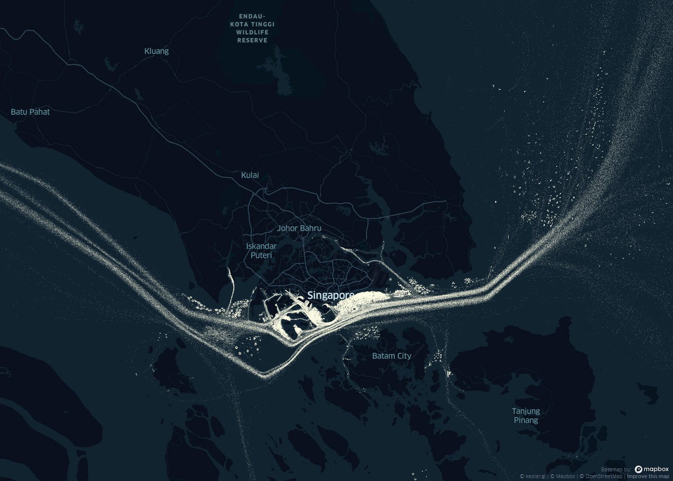
Based on an analysis of AIS data from approximately 400 ships over several months, we found that ships are sailing in unrestricted waters around 80% of the time. We targeted the remaining time, when ships are close to shore, in shallow waters or operating in areas with traffic limitations.
We developed the concept of a “typical corridor” defined by the centreline of a fairway and extending out either side as far as AIS data shows ships typically sail, with a small safety margin added. In this way, the corridor is independent of water depth data, although it is implied because ships are sailing within the corridor. It is also independent of geospatial information on hazards such as wrecks, buoys and moving sand banks. Like water depth, these features are implicitly catered for by the use of AIS data on historical ship voyages at the location.
This simplicity makes it a practical solution to operate globally, in real-time, even for operators managing the largest fleets. It is also suitable for those operators with time-chartered vessels, because it doesn’t require the installation of new equipment.
The system does not create extra workload for the crew, and can be tailored to the specific vessel size, draft and type by selectively filtering out other vessels from the “typical corridor” algorithm.
Put to the test
he cases examined is the grounding of the 12,000 TEU Ever Forward in the Chesapeake Bay in March this year when it was headed from the Port of Baltimore to Norfolk, Virginia. The grounding occurred well outside of the typical corridor we calculated, in a passage that was narrow for a ship of that draft.
Another example is the grounding of the smaller 5,500 TEU container ship Tina 1 off Batam, Indonesia, in 2020. The vessel first registered three AIS positions outside of the typical corridor over a period of 20 minutes before hitting a previously grounded ship.
These cases demonstrate a common scenario where the grounding occurs outside the typical corridor, within restricted waterways, after some indication of increased grounding risk was evident.
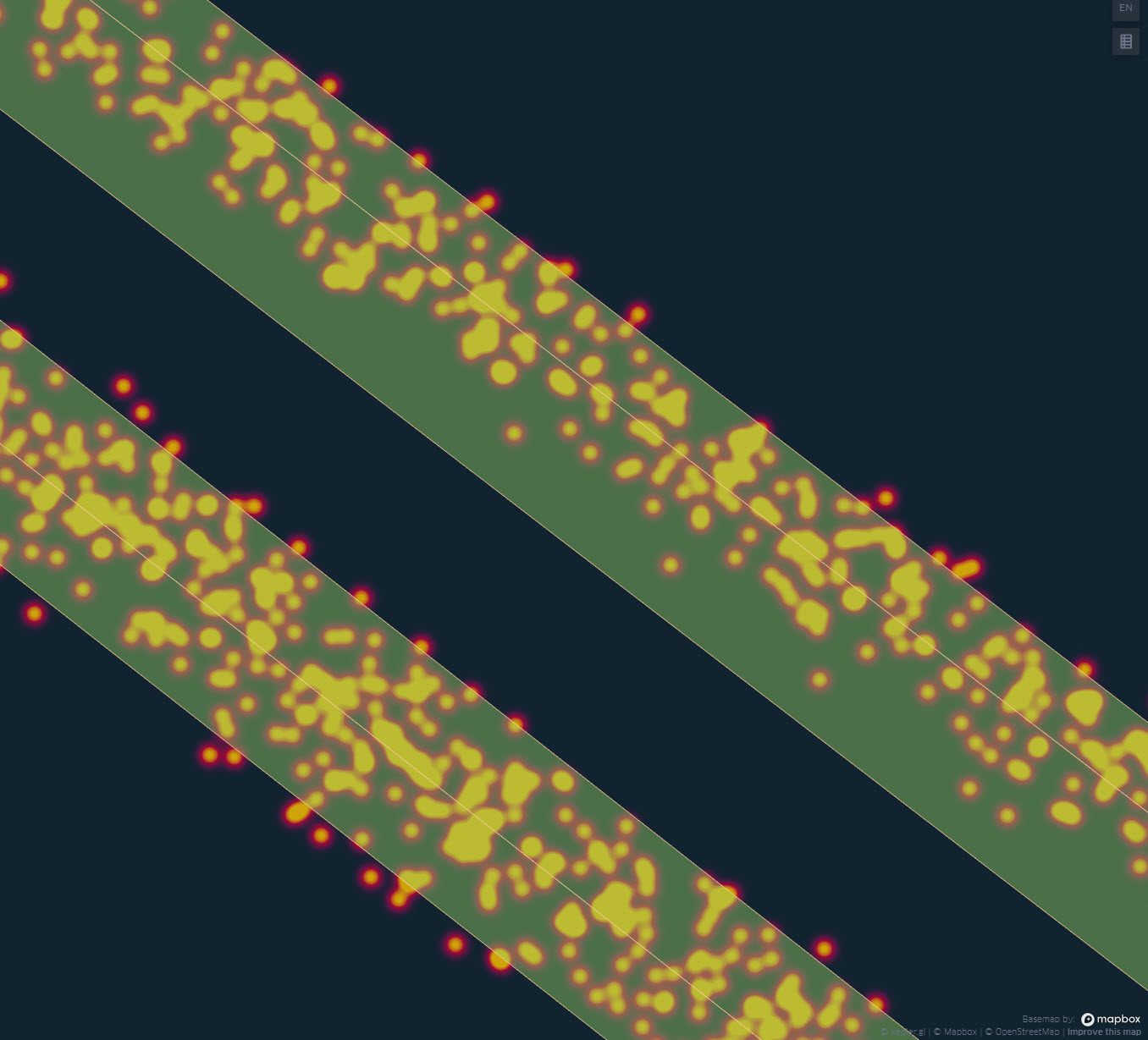
Our system correctly identified the risk in both cases.
Our holistic approach
The use of operational data as a baseline for risk detection can help identify anomalies and highlight cases where risk levels are higher. This can be highly beneficial for large fleets and can be effectively combined into a human-based monitoring setup in an onshore monitoring centre.
We see this system as a practical solution today and as a building block for further sophisticated and holistic risk detection in the future. It could be combined with water depth data, weather forecasts or anchorage area information to cover a wider range of risk scenarios.
These are steps well worth taking. According to Allianz’s Safety and Shipping Review 2022, foundering (52%), grounding (18%) and fire/explosion (13%) are the top three causes of total losses over the past decade, accounting for more than 80% of 892 reported losses. Even in cases that don’t result in total loss, the risk to human and cargo safety is high, and salvage, re-floating or wreck removal can be a complex and expensive task.
NAPA is continuing its research into systems that support ship operators and crews as they manage risks. For example, in a previous blog, we described how NAPA has developed an innovative framework to conduct a rapid assessment and real-time monitoring of operational flooding risks for passenger ships.
For over 30 years now, we have combined naval architecture, shipping and digital expertise to help ship operators make the decisions that matter.
The full paper will be available here later: http://www.shipstab.org/index.php/conference-workshop-proceedings