November 16, 2023
Voyage Optimization as shipping’s ally in increasingly challenging weather

With extreme weather events becoming more frequent, the ability to predict and adapt to these conditions is more important than ever. This builds an even stronger case for voyage optimization tools that help crews make the best possible decisions in the constantly changing marine environment. The weather may be unstable, but routing ships doesn’t have to be uncertain.
2023 is “virtually certain” to become the warmest year ever recorded, according to the European Union’s Copernicus Climate Change Service. Additionally, there is a clear long-term upward trend in average global sea surface temperatures.
What does this all mean for shipping? Climate change increases the likelihood of extreme weather conditions, meaning more frequent, stronger and often sudden storms to contend with. It can also lead to shifts in weather patterns that could affect trade routes. We are already seeing this change in action: for the first time since records began, 2023 has seen Category 5 (the highest) storms forming in all seven tropical ocean basins monitored by meteorologists.
In the face of more extreme weather events, the ability to understand, predict and adapt maritime operations to rapidly evolving conditions will increasingly become a strategic priority.
Throughout most of the history of seafaring, which dates back thousands of years, the vast ocean was an unpredictable force. But the digital era has brought more clarity in decision-making on two fronts. With the latest weather modelling tools, we are now able to comprehend the different phenomena that make clear skies or rough seas, and forecast the evolution and probable trajectories of storms. And with modern weather routing systems, we can harness that knowledge and those predictions to determine the best route to get a ship to its destination safely and efficiently.
Crucially, just like the weather itself, the assessments delivered by these tools evolve throughout a ship’s voyage. We can’t control the weather, but we can predict and adapt our voyages to ensure safe, efficient shipping. Here is how NAPA Voyage Optimization, part of our Fleet Intelligence solution, does that.
A wealth of weather data sources
A cornerstone of NAPA Fleet Intelligence lies in its sophisticated use of weather data from a variety of sources. In short, we combine high-resolution meteorological and oceanic forecasts and climatology data from our partner Tidetech, together with forecasts on the probability and trajectories of tropical storms from Tropical Storm Risk (TSR), to paint a comprehensive picture of the weather conditions, present and future.
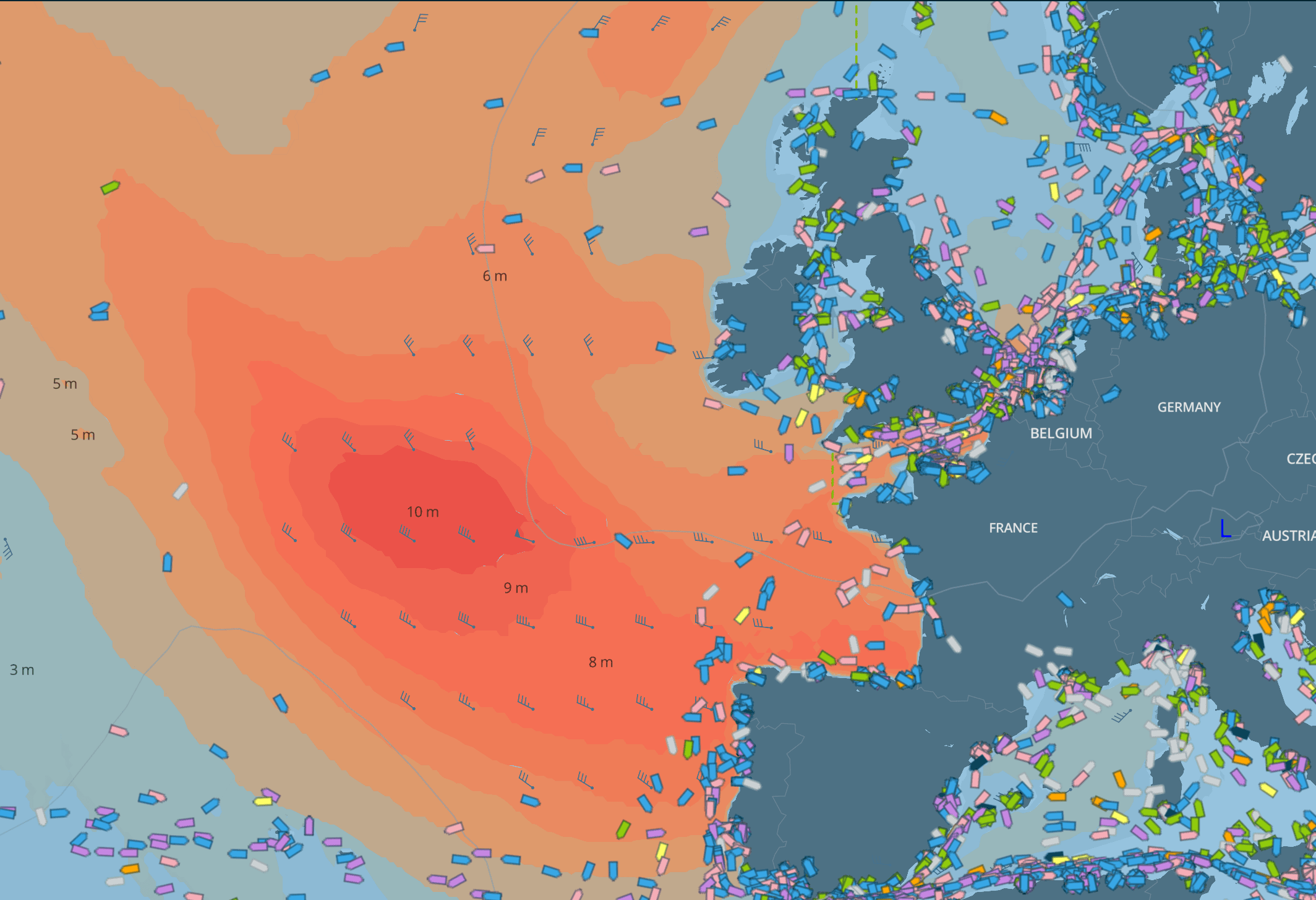
This forms the foundation of the real-time view provided to users by NAPA Fleet Intelligence, which includes:
- Wind and mean sea-level pressure
- High-resolution wave predictions
- Combined tidal and ocean currents
These real-time observations and forecasts are constantly being updated and harmonized to give the most up-to-date weather information on current conditions and predictions along the ship’s planned route. Captains can also access weather history at will, which is a valuable feature to inform their decision-making.
Furthermore, seasonal weather patterns also play a significant role in maritime navigation. As such, NAPA Fleet Intelligence uses climatology data to incorporate average weather conditions for specific times of the year into its assessments. This is particularly beneficial for long voyages, where seasonal trends for wind, waves, and currents can be utilized to optimize voyages when detailed weather forecasts are not yet available.
Adapting to extreme events
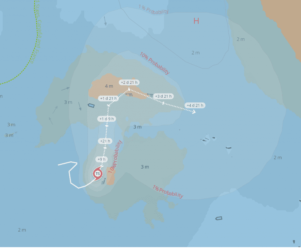
When dealing with extreme weather events, such as tropical storms, NAPA Fleet Intelligence’s tropical storm visualization comes into play. This feature overlays tropical storm information with the standard weather information already provided by the platform, offering critical insights such as:
- Past and predicted trajectory of the storm
- Predicted strength category in different locations
- Probability contours of the area that will experience tropical storm-strength winds
Data-driven decision-making
The weather visualizations provided by NAPA Fleet Intelligence empower captains to make better decisions throughout a ship’s voyage. Equipped with comprehensive, up-to-date assessments, they can steer through increasingly challenging seas. The clear and detailed visualizations offered by NAPA’s modern interface enable them to choose the best routes and adjust the ship’s trajectory to maximize efficiency and ensure safety at all times.
These granular insights include:
- Detailed atmospheric analysis: NAPA Fleet Intelligence provides critical insights into meteorological phenomena, delineating areas of high and low atmospheric pressure, charting the corridors of strongest winds, and mapping the crests of significant waves.
- Precise navigation data: the interface enables users to “zoom in” for detailed data on wind vectors, oceanic currents, and a synthesis of significant wave heights – all critical data for precise navigation.
- Integrated tropical cyclone monitoring: the system incorporates real-time tropical storm data, providing comprehensive updates on active storms, complete with strength categories assessment and wind speed ranges.
The advanced weather browser feature allows users to view upcoming weather forecasts or review conditions along a completed voyage. Moreover, the spot weather functionality enables them to pinpoint weather forecasts for any location on the map.
Thriving in the vast ocean requires not only skill and experience but also the most advanced tools that can provide vital insights to guide decision-making. This is where NAPA’s solutions are indispensable – giving captains and crews access to accurate and clear weather forecasts, informed by real-time data together with historical and seasonal patterns.
One cannot beat or control the ocean, but we can work with it. With NAPA Fleet Intelligence, we can better understand and predict the seas and optimize our voyages accordingly – allowing us to sidestep nature’s wrath with grace.